LiveMapping – Case study

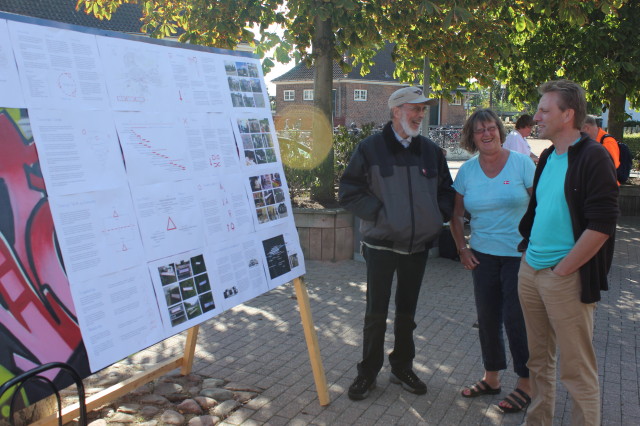
A collection of screenshot from a LiveMapping done in Hedehusene in the western suburbs of Copenhagen in 2012. The mapping was done both with street interviews and small interventions such as public meetings, walks and being part of a local market. Especially our street kitchen was an important tool as a mobile base.

DSCN1419.jpg

Continue reading “LiveMapping – Case study”

CiTyBee Business card

What would be the perfect business card for a “Business” that wants to combine a  high tech and hands on approach?

A NGO that seeks to unleash local resources?

Somebody who likes honey – don’t know why?

So you guessed it: a small bottle of honey with a QR code that leads to this page.

The honey is produced by the bees of the beekeeper Svend Grønlund in Hedehusene. If you liked it you can contact him here svend at groenlund.dk

If you want to get in touch with us go to this contact page 

City Agency

Untitled
We are working on setting up a City Agency in Hedehusene collaborating with universities in Copenhagen and engaging local citizens, municipalities, developers, media and businesses. The aim of such an agency is to strengthen the local community using methods that are locally relevant and especially trying to engage those citizens that feel alienated by the traditional consultation processes or local democracy in general.

We are looking into new ways researchers and students get down on to the streets and engage with local people. We are developing the City Agency bringing a mix of qualitative, quantitative and spatial methods into local communities involving both students, researchers, local stakeholders and local media. We want educational institutions to play a role in promoting local stewardship in a way where both the local community and students and researchers benefit.

A City Agency would be part of a emerging network of City Agencies that are mainly based in Architecture Schools in Europe – so far in Sheffield, Copenhagen, Hamburg, Berlin, Stockholm

CiTyBee online mapping tool

CiTyBee has started to make an old dream real. In collaboration with MapCentia.com we are now developing an online mapping tool that boosts the efforts to tell stories “in and about the city”. Have a sneak view on a first trial version that is using the stories told on walks and public meetings in Hedehusene 2012 here. Stay tuned for further developments

CiTyBee-Mapping

Visit from Sheffield

sheffield1_69
Friday february 22nd was spent in good company with 26 students from Sheffield School of Architecture. Instead of a presentation that showed our work in Hedehusene we involved them in a live presentation of CiTyBee.

In just 2 hours we went through all 3 phases: telling the stories about the spaces; engaging in a dialogue with the aim of identifying the most important of these stories; and acting on the outcomes of the dialogue to answer the brief of the day – How to make the station in Hedehusene more visible.

The result was impressive and played well into the activities in the afternoon when we held an open house for the local community to come and share their thoughts and ideas.

See photos on Flickr here and here

Video

Most of our activities were documented with video. We used a modified iPhone setup which was handy and discrete, but despite using a good mic our sound quality was never very good.

DSCN1419
Some of the video material was roughly edited and uploaded to our Vimeo site. Stickers with QR codes led to a Google Map where points on the map would link to the relevant video about that place.

IMG_4991

Mapping

IMG_4343

We have used mapping as a tool in our work in many different ways, first with Supertanker and now with CiTyBee. Read more about the background for how we work with mapping here

In our prototype in Hedehusene in 2012 we used no high tech GPS or smartphones. Even though we would like to do that, we think that mapping starts  with just being in public space using the best sensor for the rich sensory and emotional diversity of the city: ourselves and our senses.

We do 1 : 1 Mapping, Street Map and Patterns of Possibilities

1 : 1 Mapping

Our Street tool Box is an important instrument in our 1:1 mapping. It allows us to get around and be in public space, talk to local people and start to map the space through narratives and dialogue.

DSCN1360

The mapping became both a way of documenting stories “in about urban spaces” but it also allowed us to meet the people on their “home turf”, giving importance to a particular space. Many of the people that we met through this interaction would later go on to being involved in future dialogue and offshoots.

DSCN1392

By instantly putting up new signs or “Street Whiteboards” we would create a 1:1 map that documented the dreams, needs and interests for that space.

DSCN1393

With the new signs and the Street Kitchen we also want to create a situation that shows how a space can be taken or appropriated in order to inspire people to dream of other ways this space could be.

IMG_4344

Street Map

We use a big transportable map that can be moved around and stickers that function in a similar way to the “Street Whiteboards”.

IMG_4292

The Street Map became a feature on the monthly market in Hedehusene. It was a popular occasion for people to tell stories and point out the places related to the stories. Again the stickers are used to immediately document what has been said and encourage those who arrive later to react on what has been said earlier.

IMG_4270

Patterns of Possibilities

By the time of the first public meeting the map has become quite full with keywords that document the many stories. (This is where technology might come in handy)

IMG_4418

The map shows how many views and stories different places have and that these stories often see the same place in different ways. The map visualises the many different voices of the community and most importantly gives people a way of acknowledging these other voices. This gives a more nuanced and constructive discussion based on a better mutual understanding…hence a dialogue is created!!!

IMG_4450

People are given little blue stickers to mark what they think is important. The result is that “Patterns of Possibilities” start to emerge on the map showing the important areas and themes. This is the starting point for the rest of the public meeting that will look at what to focus on and how to act on it. Finally the new ideas and suggestions are documented on the map.

IMG_4511

Power Tools

IMG_6684

In order to make some quick prototypes we have a selection of cordless power tools – mostly various Hammer Driver-Drills but also a wonderful cordless Recipro Saw. Our aim is to get the batteries recharged with solar panels in the near future.

IMG_5107

IMG_5103

IMG_5108

Kia from Helsinki built 9 benches for a public meeting in one day!

IMG_5100

Amel brought his own tools to speed things up.

IMG_5184

IMG_5222