We have used mapping as a tool in our work in many different ways, first with Supertanker and now with CiTyBee. Read more about the background for how we work with mapping here
In our prototype in Hedehusene in 2012 we used no high tech GPS or smartphones. Even though we would like to do that, we think that mapping starts with just being in public space using the best sensor for the rich sensory and emotional diversity of the city: ourselves and our senses.
We do 1 : 1 Mapping, Street Map and Patterns of Possibilities
1 : 1 Mapping
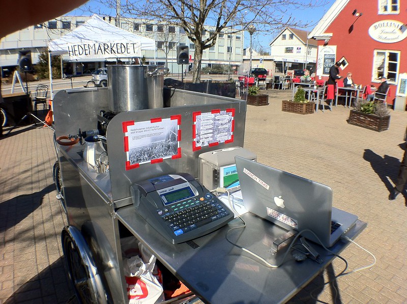
Our Street tool Box is an important instrument in our 1:1 mapping. It allows us to get around and be in public space, talk to local people and start to map the space through narratives and dialogue.

The mapping became both a way of documenting stories “in about urban spaces” but it also allowed us to meet the people on their “home turf”, giving importance to a particular space. Many of the people that we met through this interaction would later go on to being involved in future dialogue and offshoots.

By instantly putting up new signs or “Street Whiteboards” we would create a 1:1 map that documented the dreams, needs and interests for that space.

With the new signs and the Street Kitchen we also want to create a situation that shows how a space can be taken or appropriated in order to inspire people to dream of other ways this space could be.

Street Map
We use a big transportable map that can be moved around and stickers that function in a similar way to the “Street Whiteboards”.

The Street Map became a feature on the monthly market in Hedehusene. It was a popular occasion for people to tell stories and point out the places related to the stories. Again the stickers are used to immediately document what has been said and encourage those who arrive later to react on what has been said earlier.

Patterns of Possibilities
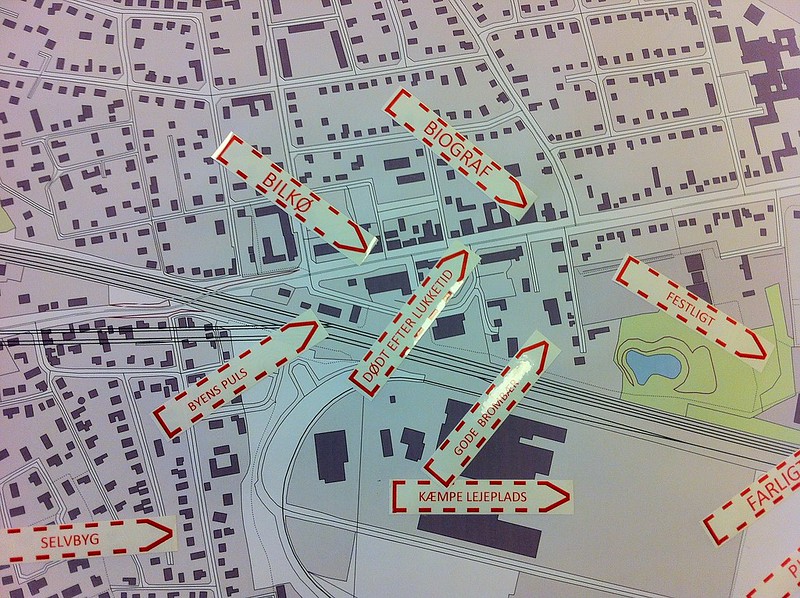
By the time of the first public meeting the map has become quite full with keywords that document the many stories. (This is where technology might come in handy)

The map shows how many views and stories different places have and that these stories often see the same place in different ways. The map visualises the many different voices of the community and most importantly gives people a way of acknowledging these other voices. This gives a more nuanced and constructive discussion based on a better mutual understanding…hence a dialogue is created!!!

People are given little blue stickers to mark what they think is important. The result is that “Patterns of Possibilities” start to emerge on the map showing the important areas and themes. This is the starting point for the rest of the public meeting that will look at what to focus on and how to act on it. Finally the new ideas and suggestions are documented on the map.